Wellington Road marks historic 200 year anniversary
By Stockport Heritage Trust 30th Jun 2026
")

Wellington Road is turning 200 this year.
It's known by Stopfordians today as a busy arterial road connecting the north and south of the borough - and, to the late Georgians in Stockport, it would have been much the same.
It's just that where once were jostling horses and carts, scurrying ostlers and a chiaroscuro of fog and lanterns, now there are electric cars, hulking 192s, and solar-powered street lamps.
The historians at Stockport Heritage Trust have provided the following article for this special milestone.
~
By Maureen Fahey
Centuries ago, Stockport's main streets comprised Bridge Street, the Underbanks, Hillgate, Millgate and Churchgate. Bridge Street took its name from Lancashire Bridge, built across the River Mersey at the boundary between Cheshire and Lancashire in the 13th century.
Comprising a single wooden span across the narrowest part of the river, the bridge dated to about 1280, and in 1374, the Bishop of Lichfield granted a licence to one 'Thomas, son of Henry of Manchester, chaplain, that he might celebrate divine service in an oratory within his hermitage at the end of the bridge at Stockport.'
At this hermitage, travellers would pay a small fee in return for which the cleric would pray for their safety. Lancashire Bridge aided the development of the town, principally the market, which then began to thrive.

The use of the word 'gate' in the other street names does not imply, as some might surmise, an entrance through walls surrounding the town, as is the case in York and Chester. In fact it derives from the Norse word 'gata', meaning a road or way. Millgate therefore was the road to the mill, which stood where Matalan is today, Hillgate was the road up a hill and Churchgate the road to St. Mary's Parish Church.
Access to Stockport from the north was via Old Road and Dodge Hill in Heaton Norris, both dropping steeply to the fording point across the river at Tiviot Dale. Having either crossed the bridge or braved fording the river, those journeying through the town then had to negotiate the narrow streets, sharp turns, steep inclines, and flights of steps that together made the tortuous passage south.
Added to this was the need to negotiate the crossing of the Tin Brook, then an open water course, which flowed across Lower Hillgate at the bottom of Rostron Brow before eventually discharging into the river behind Chestergate.
Those making their way from the south had to leave Buxton Road where it terminated at Rowcroft (sometimes referred to as 'Rowcross') Smithy in Heaviley and follow the steep descent of Hillgate to then either cross the Tin Brook, or travel along the 'Top o' th' Hill', now High Street, and use the steps at either Dumville's or Cooper's Brow to reach the town centre.
By the early 19th century, industry had developed at a rapid rate, the population of Stockport had grown considerably and so had the transport of goods by both road and canal, causing large-scale congestion in the town and on its approaches.
Lancashire Hill had been built in 1794, by-passing Old Road and linking Manchester Road with Tiviot Dale, but the benefits of this new route were negated to some degree by the construction of a branch of the Ashton Canal from Clayton, through Reddish, terminating at Heaton Norris.
The opening of this canal in 1797 brought an increase in traffic as coal and other goods were transported from the canal basin at Wharf Street.
It became obvious that a radical solution was needed but opinions were divided as to whether it would be better to widen and improve the existing roads through the town or to by-pass them altogether. Those who had shops and businesses on the old routes were of course in favour of the former option, being, understandably, concerned about the effect on their livelihoods.

In the event, the ground-breaking idea of a new road won the day.
In days gone by, gates made of wooden stakes, or pikes, were placed at strategic points across England's principal roads and, upon payment of a fee, these would be turned aside to allow carts to pass through and continue on their way. These early toll points were known as turnpikes and the income generated from the tolls funded the maintenance and improvement of the highways.
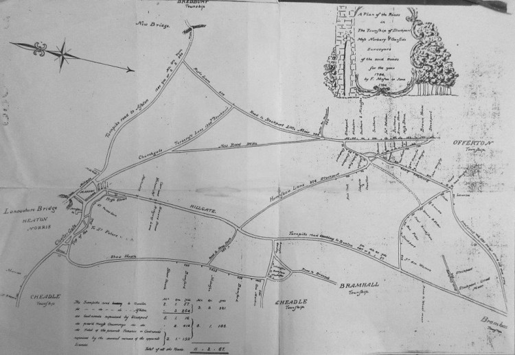
Acts of Parliament empowered Turnpike Trusts to be established and thereby fund the upkeep of the network of roads linking major towns and cities. The Manchester to Buxton Turnpike Trust of 1725 had enabled that ancient highway to be turnpiked and an Act of 1824 empowered the trustees to commission the design of a new road that would relieve the congestion through the town.
Other alternative routes having been considered and rejected, the Trust chose to build a new road which would run from the existing turnpike at Heaton Chapel in the north to Rowcroft Smithy in the south.
Construction began in April 1824 and although much of the line of the route was through open countryside, the project was not without its challenges.
The road needed to cross the valley of the Mersey, without descending to the level of the water, in order to alleviate the steep gradients on both the Lancashire and Cheshire sides of the river. This was achieved by the building of eleven arches across the valley, eight on the Cheshire side of the Mersey, one spanning the river itself, and two in Heaton Norris on the Lancashire side.
Designed by James Nowell, the project entailed the construction of a junction with Heaton Lane, which had to be raised considerably to accommodate this, and the road then followed a more gradual ascent through land belonging to W. Egerton Esquire, among others, to join the old road at Heaton Chapel.
Work had been underway for over a year when on the 26th August 1825, it was mired in tragedy due to the collapse of part of the structure which then fell into the river. Matthew Broad and Thomas Atkinson, who were working on the bridge at the time, were killed in the process and were buried together at St. Mary's Parish Church the following Sunday.
The 'noble road', some three and a quarter miles long, was completed in June 1826 at a cost of £36,000. The opening ceremony was originally planned for the 19th of that month but as that clashed with the date of the county's parliamentary elections, it was deferred until the 3rd of July and was celebrated with 'much splendour'.
To the sound of church bells and cannon fire, people flocked into the town from all directions and before long, the line of the procession thronged with excited spectators.
The pageantry began at Rowcroft Smithy, where Mr Ford, the landlord of the Wellington Arms at Blossoms Hill, on the corner of Bramhall Lane, had prepared a magnificent spread for the coachmen, guards and passengers. At 3pm, the committee of trustees began to lead the procession northwards along the new road. They were followed by over one hundred workmen, each carrying a tool of his trade, the Stockport Hussars, police, aldermen, musicians, bandsmen, the mayor, clergymen and sundry other dignitaries.
Twenty one rounds of cannon were fired, the bells of St. Mary's parish church rang out repeatedly and a balloon was released by Stockport's 'ingenious townsman', Mr Thomas Budd.
Eventually, the procession broke ranks and the coaches passed through to continue their journey to Manchester. The main body of the procession then made its way to the Warren Bulkeley Arms before dispersing to continue the celebrations at various venues across the town. The local newspaper reported that '...all retired from the scene apparently well pleased with the ceremonies of the day, which had been so arranged that all classes might participate in them.'
The afore-mentioned Wellington Arms at Blossoms Hill had been named after Sir Arthur Wellesley, the Duke of Wellington, as a tribute to his leadership in the defeat of Napoleon in the war of 1815 and, to further honour the Duke, it was decided to name the new highway Wellington Road.
A coaching inn built on the new bridge just beyond the toll house was named the Wellington Bridge Inn, to differentiate it from the hostelry at Heaviley, and was opened upon the road's completion. Eventually, the 'Bridge' was dropped from the title of the new inn and the Wellington Arms was re-named The Blossoms. So it remains today but while The Blossoms prospers, the Wellington Inn closed many years ago and is now derelict.
Next to the inn, an iron gate opened from the bridge onto steps leading down to Daw Bank. Long-since sealed off, these were known as the Devil's Steps, Old Nick having been rumoured to have appeared on them on more than one occasion. This infernal chap is also said to have frequented Turner's Steps, which lead from Little Underbank up to the Market Place.
The question of which set of steps can rightfully claim this pseudonym (or should I say 'nick name'?) is, even today, the subject of many a heated discussion! Access from Wellington Bridge to Chestergate was via another flight of steps on the east side. These were later removed and rebuilt on the opposite side of the bridge, where they subsequently became famous for having been photographed with L. S. Lowry standing at the top, looking out across Chestergate.
At the early part of the twentieth century, the River Mersey still wended its way to the west, uncovered, from the confluence of the rivers Tame and Goyt, flowing underneath Wellington Bridge and onwards to the sea at Liverpool. A road bridge had been built to link Heaton Lane (now Prince's Street) with Chestergate and in 1902, a magnificent fire station was erected on the site of the Mersey Mills, with a tramway depot behind it.
In December 1926, tragedy again visited Wellington Bridge when Fire Brigade Superintendent Howard Beckwith lost his life in a horrific accident. Beckwith, aged sixty four and very close to retirement, was answering a call in the Brigade's first motorised fire engine, the Mary Dalziel, driven by Inspector John Bushby, when the front suspension collapsed as it travelled south along the bridge.
Out of control, the vehicle veered off the carriageway and mounted the parapet on the west side, plunging thirty feet to the ground below. Three of the crew jumped to safety and two others were badly injured but Howard Beckwith was crushed beneath the fire engine, with no hope of survival.
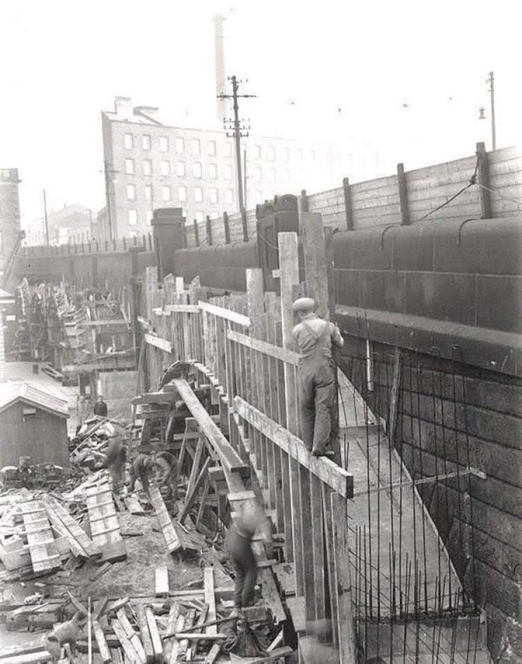
In 1935, Wellington Bridge was widened and the Bear Pit was built over the river between the two bridges.
It is worth mentioning here that ill-founded stories to the effect that this space was used for bear baiting are completely false, as it was constructed a full century after The Police Act of 1826 rendered such activity illegal.
It was in fact used for car parking, outdoor concerts, electioneering speeches, carol singing and as the venue for the civic Christmas tree. The following year, work began on the construction of a new road called Merseyway, which opened to traffic four years later and completely covered the river from Mersey Square to Lancashire Bridge.
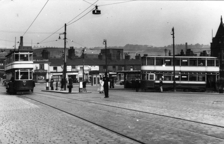
In the 1960s, the fire station and old tramways station were demolished and Merseyway shopping precinct was built along the line of the road.
Over the two centuries since Wellington Road was built, the line of the route has seen considerable development.
There have been mills, cinemas, shops, houses, schools, churches, public houses, a library, war memorial and art gallery, the infirmary, the town hall and a network of roads forming junctions with what is now the A6. Traffic has increased proportionately, especially since the 1960s when rail travel fell somewhat out of favour.
Today, the road carries an extremely high volume of traffic, so much so that Stockport's first ever by-pass now needs a by-pass itself.
~
Those interested in learning more about Stockport's heritage can visit the heritage centre Tuesday 11am – 2pm and Saturday 10.30 – 2pm. The centre is situated inside St. Mary's Parish Church, Market Place, on the left hand side past the cafe.
The heritage trust also opens the former courthouse and dungeon to the public on the second Saturday of every month, from 10.30am until 3.30pm, or when the last visitor leaves.
The trust's website can be found HERE.
CHECK OUT OUR Jobs Section HERE!
stockport vacancies updated hourly!
Click here to see more: stockport jobs


Share:
")