The history of Reddish Vale Country Park
By Stockport Heritage Trust 6th Jan 2026
")

By Maureen Fahey - Stockport Heritage Trust
Reddish Vale Country Park, known to locals simply as 'the Vale', covers some 400 acres of land.
It comprises meadows, footpaths, bridle ways, cycle tracks - including the Tame Valley section of the Trans-Pennine Trail - farmland, woodland, reservoirs and the magnificent Harrison's Weir that was built in 1791.
The River Tame, which forms the historic boundary between Lancashire and Cheshire, rises on Denshaw Moor and meanders through the Vale to the confluence with the River Goyt, near Stockport town centre.
Here it becomes the Mersey, wending its way to Liverpool, where it flows into the sea.
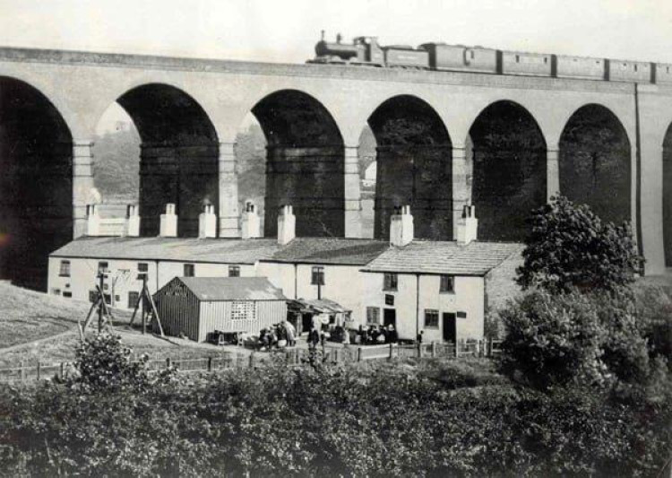
The railway viaduct crossing the river through the Vale was built in 1875 and consists of 16 arches.
Legend has it that during its construction, a witch laid a curse on the structure to the effect that anyone venturing to count the arches would suffer great misfortune. Whether that has ever come to pass is not recorded.
This railway crosses the London and North Western line just north-east of the bridge over Mill Lane that is known as the 'Giant's Moneybox' because of the slot-shaped gap between the original rail track and that which was added at a later date.

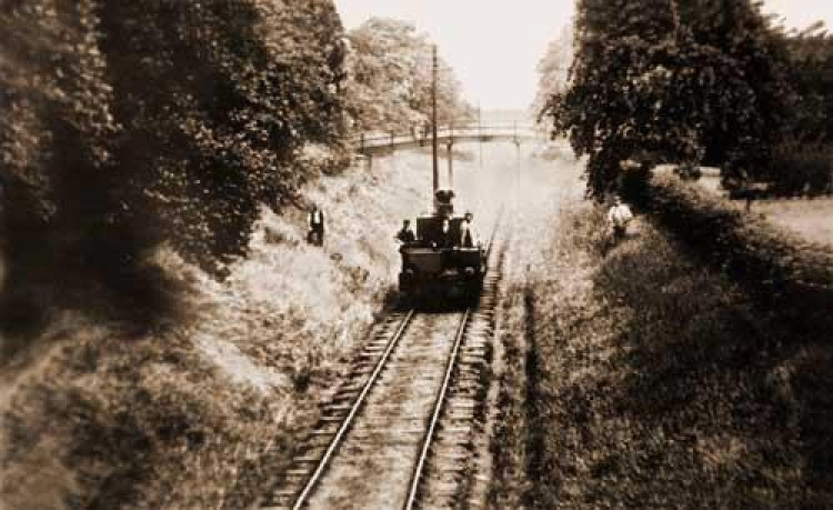
A mineral tramway ran from the convergence of the two railway lines eastwards to Denton Colliery, formerly named Burton Nook, on Stockport Road and on to Great Wood Pit.
Opened in 1853, the tramway, known as the Bogie Line, linked the coal wharf at Reddish with the collieries, crossing Denton Brook in the valley of Denton Wood on a high embankment, intersecting Ross Lave Lane and continuing behind Hyde Hall at the top of the lane to the colliery near Stockport Road. Denton Colliery closed in 1929 and the line was dismantled ten years later.
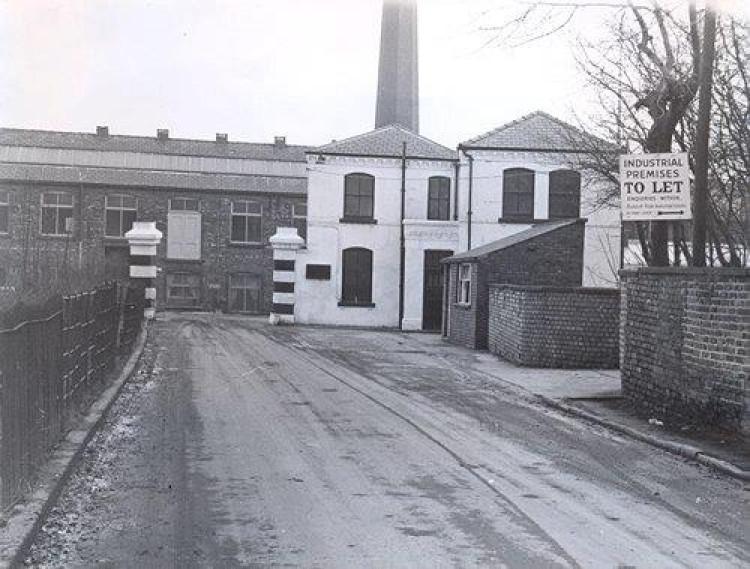
A print works lay at the bottom of Reddish Vale Road, at a bend in the river, and was opened by a Mr Frances in 1780. It comprised a range of single and two-storey buildings, with a central engine house and an octagonal brick building.
Initially, the business failed to thrive and in 1820, it was sold at auction and described thus; 'The complete and extensive printing and bleaching works called Reddish Mills and Wood End or Top Works, with two excellent dwelling houses, 18 cottages and 50 acres of land.
And also those print works consisting of a large brick building with printing rooms, stove drying rooms, cooling rooms and wash and dye houses.
Also another building, with a shell room and madder house (madder dye being a derivative of the root of the plant of that name).

Also a building containing a colour shop, two print block shops, a cutting room and a copperas house, measuring room and an air drying room over it.'
The business was run by Messrs Thorpe and Paul, then a John (or James) Fletcher. By 1840, brothers Ernest Hannibal and John Becker were running the works, equipped with four printing machines and 118 block printing tables.
Their sister Lydia, born in 1827, was a biologist, botanist, astronomer and champion of women's rights, serving as the secretary to the National Society for Women's Suffrage from 1867. Lydia is said to have lived with her brother Ernest at Sunnyside, in the Vale.
Interestingly, Elizabeth Hulme, a contemporary of Lydia, owned Spring Vale Print Works, on land later to be occupied by Tiviot Dale Station in Stockport, and reputedly employed a work force made up entirely of women.
Bradshaw, Hammond and Company of Levenshulme took over the Reddish Print Works in 1862 and in 1899, the works became part of the Calico Printers' Association, at which time the outfit boasted thirteen machines.
According to Grace's Guide, the Calico Printers' Association (CPA) was formed in 1899 by the amalgamation of forty six printing companies and thirteen mercantile concerns. In 1868, the CPA merged with the English Sewing Cotton Company to become English Calico Ltd. In 1873, it became Tootal Ltd and eventually, a merger formed Coats Viyella plc.
Printing at Reddish Vale ceased in 1975 and the buildings were subsequently used by various businesses, including Pollard's Brewery, before demolition in the early 1980s. Reddish Vale was acquired by Stockport Metropolitan Borough Council in 1995 and in 1999, the site of the print works became a butterfly field.
Print works tended to be located in areas with few or no houses and so industrialists often built accommodation for their work force. Tame House, just west of the print works, was the home of the works manager and later, the offices of the CPA. It was derelict for some time but is currently a private residence. Just past Tame House, a row of cottages lined River View and were occupied by print workers. These ancient dwellings were demolished in the 1960s.
Print workers also occupied the cottages on Reddish Vale Road, opposite Reddish Vale Farm.
Earmarked for demolition, these lovely cottages were saved in 1979 by the efforts of John and Kit Byrne, twin brothers from Reddish who had an abiding love for the Vale and its environs.
The farm, which once housed a dairy herd, is now a very popular animal farm and riding stables.
There was also a row of cottages known as the Nine Houses, two later being knocked into one.
These stood south of Ross Lave Lane, immediately west of where the railway line runs now, and were occupied mainly by print workers and labourers, then later by railway construction workers. The Nine Houses were demolished around the time of WW1.
A short distance upstream from the Nine Houses was Strines Weir, with Strines Farm and cottages nearby, south of the river. The weir was destroyed by a flood in the 1960s but the sluice gate survived and is still accessible, while the farm buildings were demolished in 1939.
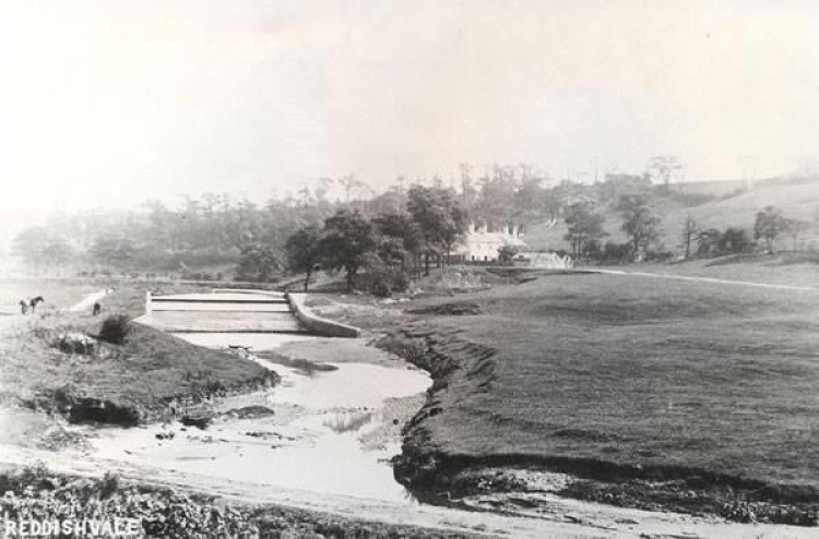
The weir serviced the manorial corn mill from which Mill Lane, which leads into the Vale from North Reddish, takes its name.
A system known as 'mill soke' entitled the lord of the manor to constrain his tenants to have their corn ground at his mill and to pay a fee for the privilege.
The manorial mill at Reddish was first mentioned in a charter thought to date to the late 13th century (charters generally being undated) and probably occupied the site of the later building which is said to have straddled the water at the point close to where Denton Brook flows into the Tame.
Accounts and opinions vary as to the precise location of this mill but the 1848 map shows it to be immediately south of the junction of Mill Lane and Ross Lave Lane.
Around 1810, this building was converted to a school and became known as The Ark because water could be seen through the gaps in the floor boards.
The Ark is thought to have been taken down in about 1860 to enable new reservoirs to be built.
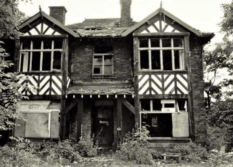
To the west of the Vale stood Reddish Hall, home of the Reddish family. The half-timbered, three-gabled, moated hall was demolished circa 1780 and Reddish Vale School now occupies the site. Hyde Hall, mentioned earlier, was the home of the Hyde Family of Denton and was later occupied by a succession of tenant farmers.
This Grade 2 * listed building, dating to the 16th century, now stands empty and derelict and is on the Buildings At Risk Register. Denton Hall stood nearby, off Windmill Lane; this dated to the 15th century and was owned by the de Holland family, then by the Egertons, the latter becoming the Earls of Wilton.
Denton Hall Farm later occupied the site of the hall and was run by the Oakden family for many years until 1977, when they were given notice to leave. After the Oakdens had gone, the house and farm buildings were left to become derelict and were extensively vandalised.
In 1979, the west wing of the farm was dismantled and rebuilt at a property in Alderley Edge while the rest of the buildings were demolished. Today, the site is an industrial estate. Arden Hall, home of the Arderne family, overlooks the Vale from Castle Hill, on the border of Denton and
Bredbury. The current building, surrounded by vestiges of the ancient moat, dates to 1597. The family's town house was Underbank Hall, now Nat West Bank, on Great Underbank in Stockport.
Today, despite the efforts of government bodies, developers and speculators over the years, the Vale has survived. It became a country park in 1995 and as a nature reserve, it is home to all types of wildlife.
Along with the more common garden birds, there are sand martins. Kingfishers, herons, swans, cormorants, woodpeckers, coots, moorhens and gold crests. Otters have been sighted near Tiviot Dale and there are deer, foxes and badgers, along with the occasional predatory mink, living in and around the country park. Parking is free and refreshments are available from Thursday to Sunday, courtesy of the hugely popular Coffee Bean Dream, based at the bottom of Reddish Vale Road.
~
Those interested in learning more about Stockport's heritage can visit the heritage centre Tuesday 11am – 2pm and Saturday 10.30 – 2pm. The centre is situated inside St. Mary's Parish Church, Market Place, on the left hand side past the cafe.
The heritage trust also opens the former courthouse and dungeon to the public on the second Saturday of every month, from 10.30am until 3.30pm, or when the last visitor leaves.
The trust's website can be found HERE
~
Free from clickbait, Stockport Nub News is a quality online newspaper for our town.
To get our top stories in your inbox each week, subscribe to our free weekly newsletter HERE.
Please consider following Stockport Nub News on Facebook or X
CHECK OUT OUR Jobs Section HERE!
stockport vacancies updated hourly!
Click here to see more: stockport jobs


Share:
")
")